[The Mori-Panee as it enters the Khoond: p27.jpg]
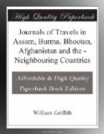
The Koond is apparently formed by the Deo-panee and Mori-panee. In the rains it must be a rather striking object, now however it is at this season, lost amidst the fine surrounding scenery. How the Faqueer’s Rock and the rock between it and the Mori-panee were detached, is difficult to say. It is evident, however, that formerly the two rivers were not united to form the Koond as at present, but that they had each their own channels when the Faqueer’s Rock must have stood between them. In fact both channels, in which water has flowed, still remain. My broken Thermometer pointed out the low temperature of the Lohit water, and 208 degrees was the point at which water boiled in two experiments. All attempts at passing along the river on this side would be vain, owing to a cliff which is totally impracticable. The Mishmees know of no rivulet called the Mtee; probably this has been mistaken for the Mishmee name for water, Mchee. The way Wilcox went I am at a loss to ascertain; as he could not have passed the Koond, he must have gone above it; although the hills are said to be impracticable for loaded coolies.
Oct. 25th.—The Koond is obviously little frequented. I left sometime after the coolies, pursuing the path leading to Ghaloom’s, which extends to the eastward. An hour and a quarter brought me again to the Laee-panee, and three hours and a half to Laee Mookh: from this place to Jingsha Ghat is scarcely an hour’s walk. The day’s journey occupied about five hours inclusive of stoppages: the distance is probably about twelve miles. I came to the determination of returning, owing to the known difficulty of the route pursued by Wilcox, and the impossibility of making a collection of grain. The Tapan Gam, or Lord of the Koond, particularly insisted on the impossibility of ordinary coolies going this way, and as he offered men to bring up grain from the plains, I at once acceded to his proposal of making a granary in his village. This man had no delicacy in asking for presents: he at once said, “You must give gold, silver, and every thing in the calendar of presents to the Deo,” meaning himself. As I found it impracticable to satisfy him, I sent him off with a small present, promising more when he should have amassed the grain. His brother, a tall, stout, and much more useful man, (as he does not refuse to carry loads,) on seeing me rub salt on a bird’s skin, remarked, “What poor devils we are! Bird’s skins with salt supply the Sahibs with food, while we can’t get a morsel.” They promised to take me all over the country, and to be my slaves, if I would point out to them where salt is to be found.


