From the ridge, a rather extensive view to the south is obtained, extending to the Khyber fort, which is of the ordinary square form, and just below it, a tower and house. To the east, and all around a good deal of cultivation occurs; also several high ridges, say 7,000 feet; one terminating 4,000 feet above us, presents a very rugged outline with the appearance of rather large trees. The road up to the ghat is visible, as well as the Choky and a fort, with a small sheet of cultivation to the eastward. Beyond this a ravine, then two other ridges, of which the nearer one is high. The Cabul river passes to the NNW., and Lalpoor lies to the north. One peak and a small piece of ridge of Hindoo-koosh, white with snow, is seen very distinctly though distant, it must therefore be very lofty; far more so than any part we have seen to the westward.
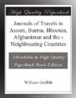
[Khyber Pass: p425.jpg]
Description of the annexed map of the Khyber Pass.
A. Kumdhukta. By this is Abkhanah route.
B. Little Khyber ghat, on Peshawur side.
C. Khyber ghat, entrance on the Jallalabad side.
D. Kurraha route.
E. Direction of Sofaid-Koh in the distance.
F. Flagstaff in the middle of the Pass.
The ground between the dotted lines and river, on the south, is, or has been cultivated. The ground near the river on the north side is covered here and there with brown grass. About the Flagstaff, sand and short dried up grass occur.
The general character of the hills in every direction except the snowy range, is bluffly rounded, very bare, and brown, with here and there a shrub.
That which Burnes calls Noorgil, is the range of Kareaz, and is distinct from Koonur. Kashgur lies beyond the snowy range.
The inhabitants of the mountains, like those of Lalpoor, wear sandals made of the fibres of Chamaerops, which is common: one plant of Ephedra used for snuff?
3rd.—Proceeded to one mile beyond Ali-Musjid. The ascent commences immediately where the Choky is seen from the camp, by a very good road cut out of slate rock; the rocks are steep on both sides, and very zig-zag; a short partial descent in one place occurs to a small pool of water. From the Choky, a descent takes place by a similar road for perhaps two miles, until the ravine which we left at camp is turned; this is thence followed, occasionally leaving it where the road is bad and runs through low rugged hills. The road then after passing some of the old ruins opens out into a space with cultivation. Close to this is the highest spot of the pass, surrounded by low hills, none higher than 500 feet. Cultivation occurs especially at Lal-Ghurry Beg, a space of some size, containing several villages, of the usual Khyberry form, namely, surrounded by low, quadrangular walls, with a thin square tower and very broadly projecting eaves. A short distance from its summit, just after passing the villages, and before entering the ravine which leads us to our present camp is a Khyberry tower, built on a fine Bactrian tope, which is nearly half ruined; on the top of this a dome of good proportions is built on a double-terraced foundation.


