------
Figure
Mt.  Veronica and Salapunco, the Gateway to Uilcapampa
------
A league below Ollantaytambo the road forks. The right branch ascends a steep valley and crosses the pass of Panticalla near snow-covered Mt. Veronica. Near the pass are two groups of ruins. One of them, extravagantly referred to by Wiener as a “granite palace, whose appearance [appareil] resembles the more beautiful parts of Ollantaytambo,” was only a storehouse. The other was probably a tampu, or inn, for the benefit of official travelers. All travelers in Inca times, even the bearers of burdens, were acting under official orders. Commercial business was unknown. The rights of personal property were not understood. No one had anything to sell; no one had any money to buy it with. On the other hand, the Incas had an elaborate system of tax collecting. Two thirds of the produce raised by their subjects was claimed by the civil and religious rulers. It was a reasonable provision of the benevolent despotism of the Incas that inhospitable regions like the Panticalla Pass near Mt. Veronica should be provided with suitable rest houses and storehouses. Polo de Ondegardo, an able and accomplished statesman, who was in office in Cuzco in 1560, says that the food of the chasquis, Inca post runners, was provided from official storehouses; “those who worked for the Inca’s service, or for religion, never ate at their own expense.” In Manco’s day these buildings at Havaspampa probably sheltered the outpost which defeated Captain Villadiego.
Before the completion of the river road, about 1895, travelers from Cuzco to the lower Urubamba had a choice of two routes, one by way of the pass of Panticalla, followed by Captain Garcia in 1571, by General Miller in 1835, Castelnau in 1842, and Wiener in 1875; and one by way of the pass between Mts. Salcantay and Soray, along the Salcantay River to Huadquina, followed by the Count de Sartiges in 1834 and Raimondi in 1865. Both of these routes avoid the highlands between Mt. Salcantay and Mt. Veronica and the lowlands between the villages of Piri and Huadquina. This region was in 1911 undescribed in the geographical literature of southern Peru. We decided not to use either pass, but to go straight down the Urubamba river road. It led us into a fascinating country.
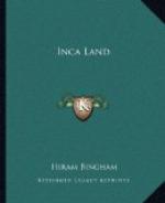
Two leagues beyond Piri, at Salapunco, the road skirts the base of precipitous cliffs, the beginnings of a wonderful mass of granite mountains which have made Uilcapampa more difficult of access than the surrounding highlands which are composed of schists, conglomerates, and limestone. Salapunco is the natural gateway to the ancient province, but it was closed for centuries by the combined efforts of nature and man. The Urubamba River, in cutting its way through the granite range, forms rapids too dangerous to be passable and precipices which can be scaled only with great effort and considerable peril. At one time a footpath


